 Sargassum (sargassum) are brown algae that grow in the Sargasso Sea, off the coast of Florida and the Bahamas, where they get their name from. Some floating species then drift in a long belt that sometimes extends for thousands of kilometers on the surface of the sea depending on ocean currents and winds..
Until 2010 they developed mainly in their region of origin, the Sargasso Sea. In 2011, for a reason probably linked to human pollution, but not only, the Sargasso Sea overflowed. Sargassum formed a second sea in the ITCZ (Intertropical Convergence Zone) in the north of Brazil.

Extension of sargassum since 2011
In these hot waters, these brown algae now grow all year round and wash up by millions of tonnes on coasts over 30 Caribbean countries and from Florida to Brazil. They then decompose quickly, causing an ecological, economic and health disaster. The problem also affects certain African coasts. But today no one knows exactly why the sargassum exploded like this 12 years ago.
Research
Gustavo Goni, of Atlantic Oceanographic and Meteorological Laboratory of the NOAA (¹), talks about the record volumes of sargassum that scientists have detected floating at sea in the first months of the year 2023. They peaked around March, thereafter, in a very unusual way, the glut of sargassum has started to diminish. Yet, it remains difficult to predict the extent of sargassum decomposition in a given year. Since March 2023 scientists using satellite data observed a decrease in the total abundance of sargassum.
Scientists follow the evolution of sargassum in the smallest details. The monthly newsletters of the University of South Florida (²) indicate that there is a significant amount of seaweed on beaches this year 2023, compared to most previous years, although the volume at sea has decreased recently, falling from 15 % between April and May. Further declines expected in July and August, but researchers say it's difficult to know exactly how much will end up on land.
The big questions – what influences sargassum blooms and why more sargassum washes ashore from year to year – remain key areas of scientific research, and there are no clear answers on this yet.
Terrestrial information
five years ago, Christine Jimenez-Mariani, a French retiree living in Cancun, Mexico, created Sargassum Monitoring® (³), a website that offers a live map (⁴) of seaweed strandings reported on beaches. His site is visited a million times per month, she said, and she also shares photos on Twitter, Facebook, TikTok and other social media sites. She spends her days volunteering to sort and put online photos and videos showing piles of sargassum, from hundreds of contributors.

Extract from the sargassum map. (Courtesy of Sargassum Monitoring®)
This website is particularly useful for boaters, informing them daily of the state of the beaches and anchorages they might want to visit.
NOAA publishes regularly updated Sargassum report online (¹). She collaborates with the University of South Florida to produce this information, and the university also publishes separate data from satellite monitoring. These reveal that the sargassum belt was particularly extensive in the month of May in 2018, 2021 and 2022, while it was a little less so in May 2023. Chuanmin Hu, researcher at USF, explains that many factors can influence the growth and flow of sargassum, as well as their arrival on a beach, from light levels to ocean currents, passing by the winds, temperature and tides.
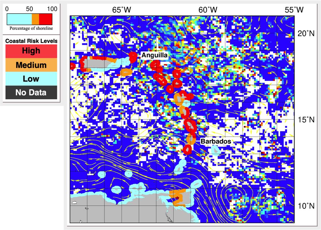
Weekly predictions for the Lesser Antilles (example)
According to Alfred Lea, researcher at the University of Texas Medical Branch, decomposing sargassum found on beaches can emit ammonia and hydrogen sulfide gases, which may irritate the nose and throat or cause difficulty breathing in people with asthma or other sensitivities. But the breezes that blow on most beaches naturally dilute these gases, which significantly reduces the risk.
L’information maritime
For recreational sailors crossing the Atlantic from Europe to the Caribbean and vice versa, Sargassum beds represent above all a obstacle to navigation. Thick slicks of sargassum can go so far as to stop boats, clump on propeller shafts, keels and rudders. Many ocean runners have had the painful experience. And getting into the water to clear this algae can represent a health risk.
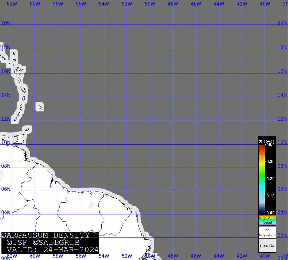
L’USF (²) publishes daily reprocessed satellite images from the monitoring of sargassum beds. These images are public and free. The developer of SailGrib, Henry Laurent, retreats these images in turn to make highly compressed images, can be downloaded and displayed as an overlay in applications SailGrib WR (Android) or Adrena (Windows), or simply in the app Apple Photos (iOS/macOS). They are then posted online regularly (⁵).

Most recent satellite location of sargassum (SailGrib)
The image is sufficiently compressed, about 100 KB, to be able to download offshore with an Iridium GO!®, either directly in SailGrib WR, either via the SailDocs service by an email request from the application Iridium Mail & Web :
-
- mailto : query@saildocs.com
- subject [free] example : sargassum
- object : send http://gribserver.sailgrib.com/sat/sargassum_density_most_recent.jpg
A GIF file of 30 last days is also available, but only with a fast internet connection (±14 MB) (⁵).

This excellent service allows sailors crossing the North Atlantic to know the areas where sargassum is present in order to follow their movement and try to avoid them..
–––
(¹) Atlantic Oceanographic and Meteorological Laboratory
(²) University of South Florida
(³) Sargassum Monitoring®
(⁴) Sargassum Monitoring maps
(⁵) http://gribserver.sailgrib.com/sat/sargassum_density_most_recent.jpg
http://gribserver.sailgrib.com/sat/sargassum_density_most_recent.gif
–––
Sources : Wired relayed by Geogarage blog
–––