
![]() NavimetriX is the world's first navigation application featuring a unified multi-system 3D graphical interface, synchronized in real time on all devices.
NavimetriX is the world's first navigation application featuring a unified multi-system 3D graphical interface, synchronized in real time on all devices.
The new navigation and weather routing app NavimetriX has just been published. The result of an extensive development work, This application revolutionizes boating on both mobile and desktop devices with its universality. It provides a unique user interface., featuring sophisticated graphics, for all operating systems : Android, iOS/iPadOS, macOS and Windows. In addition, regardless of the devices used, a single account allows full synchronization of settings and data.

NavimetriX on macOS (large screen), Windows (Laptop), Android Samsung (TabS5e), iPad (9and generation), iPhone (12 Mini)
A bit of history
Let’s remember, in October 2022, Henry Laurent (SailGrib) and Olivier Bouyssou (Weather4D) they teamed up to create eSail4VR, a dedicated gaming app Virtual Regatta. The application is already revolutionary because it is multi-platform, synchronized across all devices, with a stunning 3D interface. It is released the day before the start of the Route du Rhum. Acclaimed upon its release, it will be propelled with the Vendée Globe 2024, used by thousands of players to whom it provides crucial decision support thanks to an expert routing engine, equipped with numerous fine adjustments, while remaining easy to use for a novice. The two friends will not stop there, this will be the mock-up of the future real navigation application. Three years of developing and implementing a high-level back-office infrastructure and NavimetriX was born.
Multi-supports, multi-OS, unified navigation
NavimetriX works with the following operating systems and processors :
- macOS : Version 13 and higher, x86_64 processors, x86_64h one arm64. Compatible with macOS Monterey (released on 25 october 2021) and all later versions.
- Windows : Version 10 (build 1809 —10.0.17763) or higher, Windows 11 (all versions), x86_64 and arm64 processors.
- Android : Version 9 (API 28) up to 15 (API 35) – arm64-v8a, x86_64, x86, and armeabi-v7a, Android 9 released in August 2018.
- iOS : Version 16 or higher, processors – armv8, arm64.
These OS versions are prerequisites for running NavimetriX, corresponding to compatibility with development tools. However, they do not guarantee that the application will be fully compatible with the multiple devices available on the market. Several other factors can affect performance and compatibility, such as insufficient RAM, a poor graphics processor, etc. NavimetriX requires substantial graphical and functional capabilities. It is advisable to take advantage of the free week to test all available functions.
Synchronized
Synchronization works in real time if the devices are connected to the same Wi-Fi router, on land as well as at sea. Most settings made on one device are immediately applied to the others, except for some that need to be adjusted locally depending on the type of mobile device. Many parameters allow customization according to the characteristics of the boat used, even the ship icon, which can take the form of a monohull, a catamaran, or a trimaran. Downloaded GRIBs, POIs, routes and routings, are also synchronized instantly : no more tedious re-entry from one device to another.
All these functions, in addition to downloading weather files and charts, are supported by a powerful infrastructure of high-availability servers (¹), designed to handle large volumes of transfers. Already operational for several months for Weather4D, SailGrib and eSail4VR, this infrastructure has been subject to special security measures designed to ensure continuity of service to users.
Weather routing, spearhead of the application
The routing options and settings have been enhanced thanks to the work done for eSail4VR with expert mode, and also developments made in SailGrib based on experience acquired during cruising races. There you can find the pivot points, exclusion zones, slow zones, and numerous advanced settings for a high level of precision. Routing table generation is automatic, accompanied by a table of cross statistics TWA/TWS and even on-demand creation of a AI-generated briefing. This detailed analysis includes a link opening a frontology map covering the relevant routing area from NOAA, and also the Sea bulletin from Météo-France.
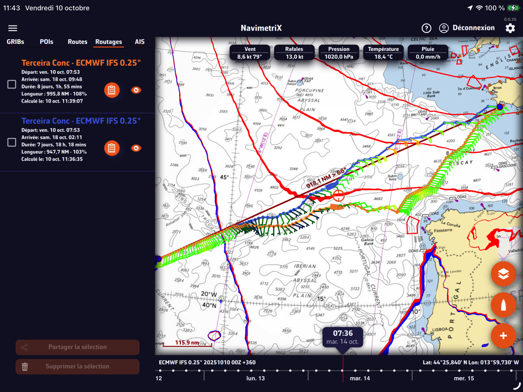
Routings with an option from a pivot point
NavimetriX combines the best of both SailGrib and Weather4D applications, in a high-quality graphical interface, and much more : wind display options animated particles or vectors/barbs, Timeline for scrolling forecasts and simulated progress of the boat on routes and routings, retractable side drawers, etc.
Charting
Like SailGrib and Weather4D, NavimetriX uses the cartography provided by the platform Geogarage under the same conditions. This cartography, based on data from official hydrographic services – more than twenty worldwide – is updated approximately four times a year. A complementary vector cartography offer should see the light of day soon.
Where ? When ? How ?
NavimetriX is available to download on the four stores : Mac AppStore, App Store, Google Play and Windows Store, or directly from the application website. The download is free, all options usable during 7 days, then in a free degraded version, or in full version by auto-renewable annual subscription at the price of 79,99 € .
The first version 1.0 will include all essential functions, mais de nombreuse fonctions sont d’ores et déjà en cours de développement et viendront enrichir l’application dans les tous prochains mois.
It is important to note that NavimetriX is a new application developed, just like eSail4VR, by the company SOFT4SAIL. It does not replace SailGrib, nor Weather4D, which remain maintained and supported, but which will no longer receive any major developments in the future. There is no link between these applications apart from the import-export of data.
–––
(¹) Back-office
–––